Key Features of VTI SkyTracker II:
✔ Professional Data Analysis: Process high-resolution aerial imagery with advanced algorithmic processing for precise measurements and mapping.
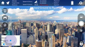
✔ Real-Time Monitoring: Access live drone telemetry and geo-referenced imagery for immediate situational awareness during operations.
✔ Cloud Integration: Automatically sync captured data with cloud storage platforms for secure backup and collaborative workflows.
✔ Cross-Platform Compatibility: Supports Windows, macOS, and mobile platforms with consistent performance across devices.
Frequently Asked Questions:
✔ What file formats does SkyTracker II support?
- The software handles common formats including GeoTIFF, JPEG2000, LAS/LAZ point clouds, and native drone camera RAW files.
✔ Can I integrate SkyTracker with GIS platforms?
- Yes, export processed data seamlessly to ArcGIS, QGIS, and other major geographic information systems.
✔ Does it support autonomous flight planning?
- Full integration with major drone autopilot systems enables automated mission planning and execution.
Powerful Aerial Intelligence:
Transform raw aerial captures into actionable insights with VTI SkyTracker II's sophisticated processing engine. Ideal for professionals requiring centimeter-level accuracy in topographic surveys, crop health analysis, or infrastructure inspections. The software's advanced photogrammetric algorithms deliver survey-grade results without specialized hardware requirements.Version 1.1.0 Release Notes: Updated March 9, 2024
• Enhanced orthomosaic stitching algorithm for improved accuracy • Optimized memory management for large dataset processing • Added support for latest drone camera profiles • Resolved minor UI responsiveness issues
Experience professional-grade aerial data processing with VTI SkyTracker II - download the latest version today to leverage these improvements in your workflow.