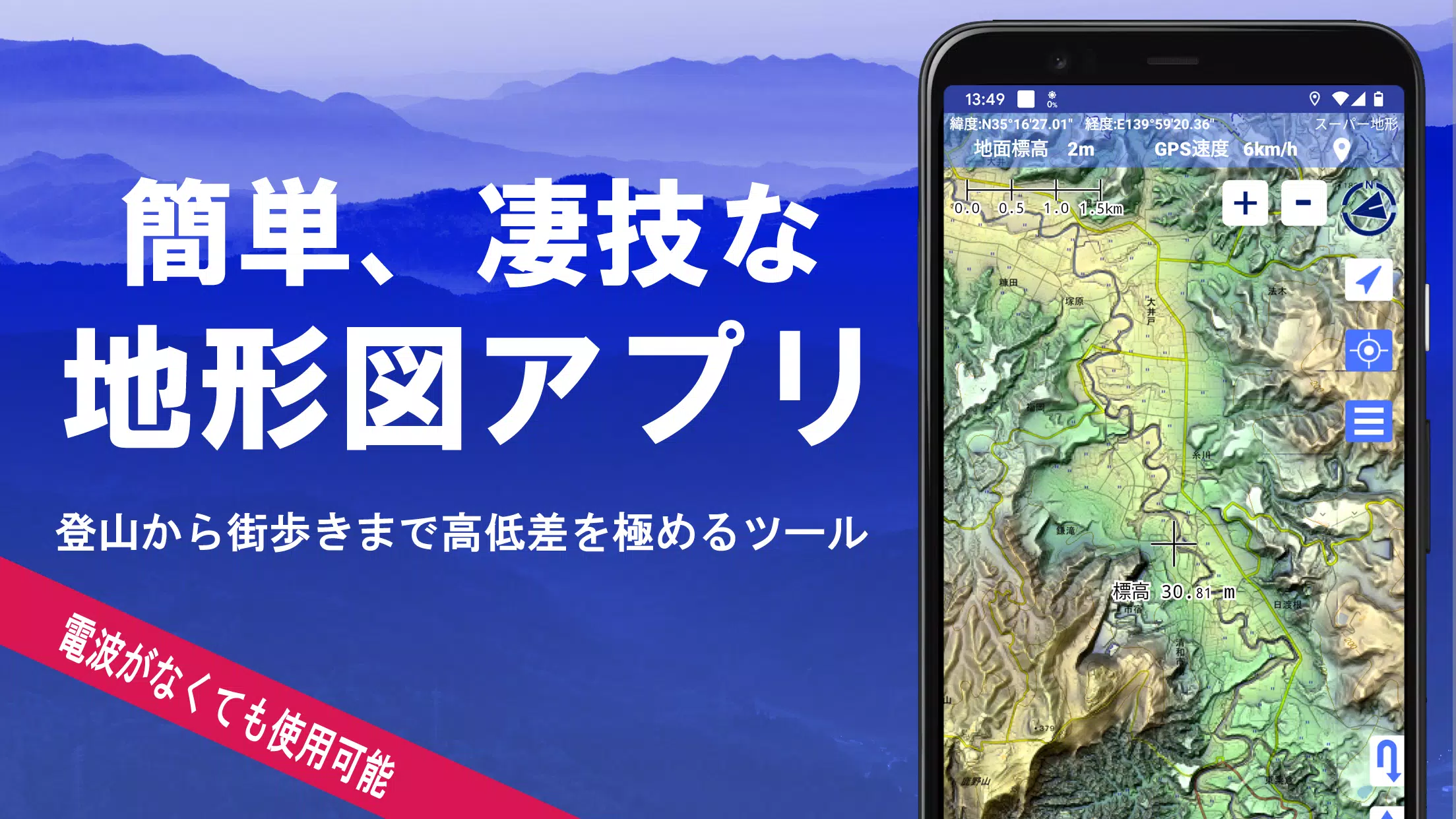
Utilize over 100 map types, including official Geographical Survey Institute maps. Perfectly suited for maximizing elevation insights, from mountain hiking to urban exploration.
Recipient of the 2018 Best Work Award from the Japan Cartographic Society.
- Access "super terrain data," which accentuates landforms through proprietary technology.
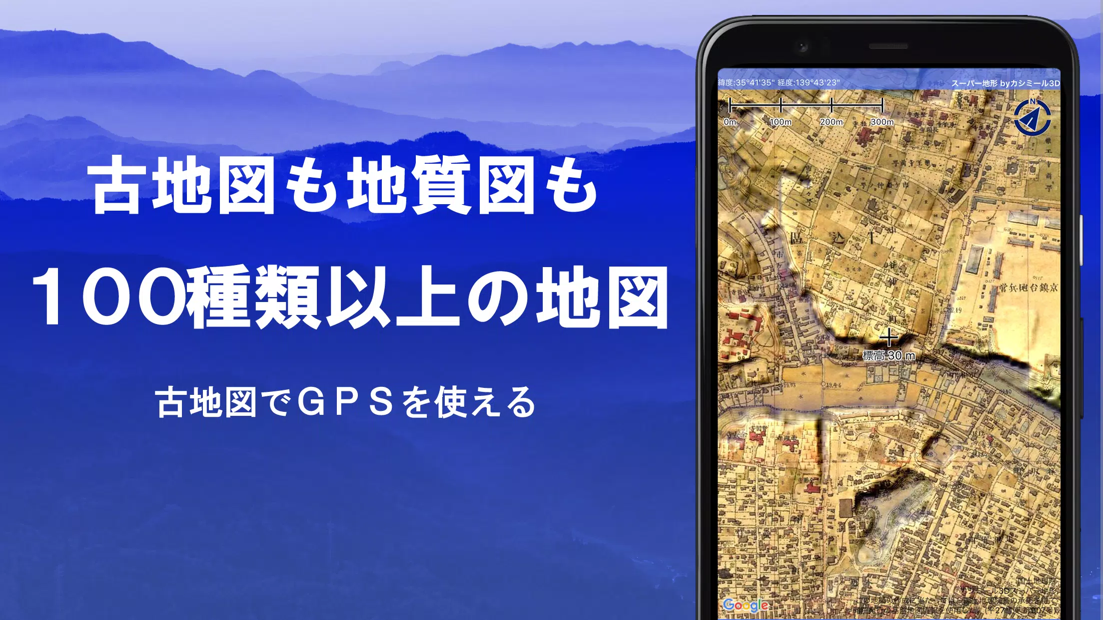
- Utilize a range of maps from the Geospatial Information Authority of Japan, such as standard maps, topographic maps, geological charts, historical maps, comparative past/present maps, and pre-war topographic surveys.
- Record GPS tracks (trajectories). Features include GPX log import/export and comprehensive editing tools.
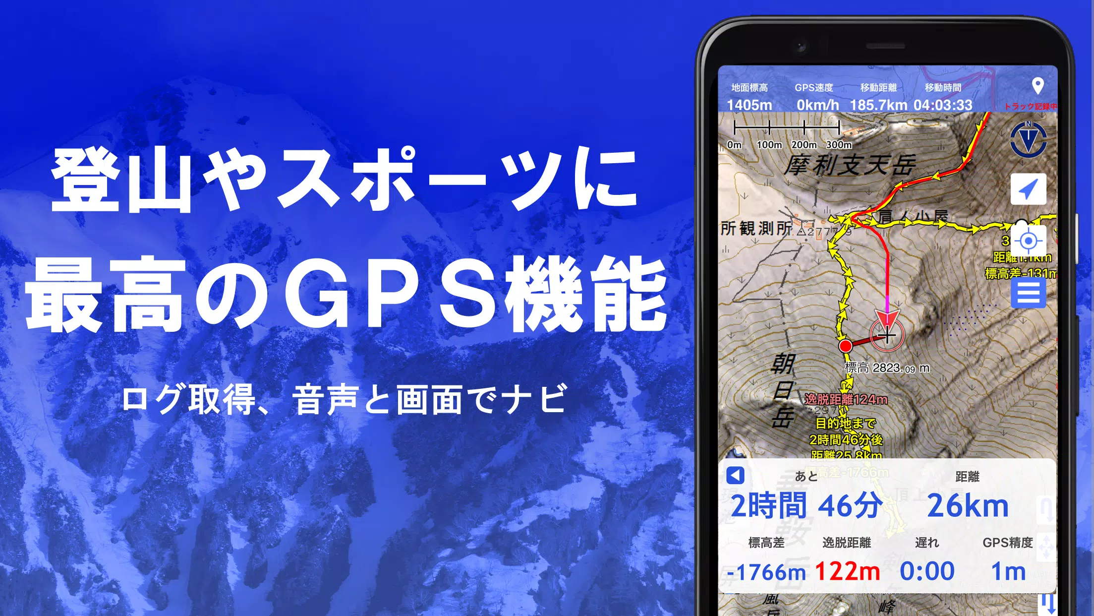
- Equipped with dedicated functions for urban walking, hiking, and outdoor activities, including voice-guided GPS navigation and data logging/editing.
- Features a visibility analysis tool for creating cross-sectional diagrams, planning observations, or radio communications. Displays building data where available.
- Includes a 360° panoramic viewer with mountain identification. Also displays the sun, moon, and GPS point locations.
- Full GPS functionality, bulk map downloads, and map caching for reliable offline use in areas with no signal during outdoor adventures.
- Geotag photos by linking them to specific map points.
- Display contour lines generated from elevation data.
- Show MGRS grid (UTM grid) overlays.
- Read, display, and edit GIS data from GeoJSON files.
- Create custom shapes directly on the map.
- Fully functional for international use.
- Print maps or export them to PDF.
- Supports a dark theme.
1. An Extensive Library of Usable Maps
Available maps (over 100 types, including combined formats)
Includes proprietary super topographic data, Geospatial Information Authority maps, hazard maps, and more.
*For aerial photography (sorted by era), coverage may vary by time period. "Latest" and "circa 1974" eras offer relatively broad coverage.
*Super terrain data maps are free to use for 5 days following app installation.
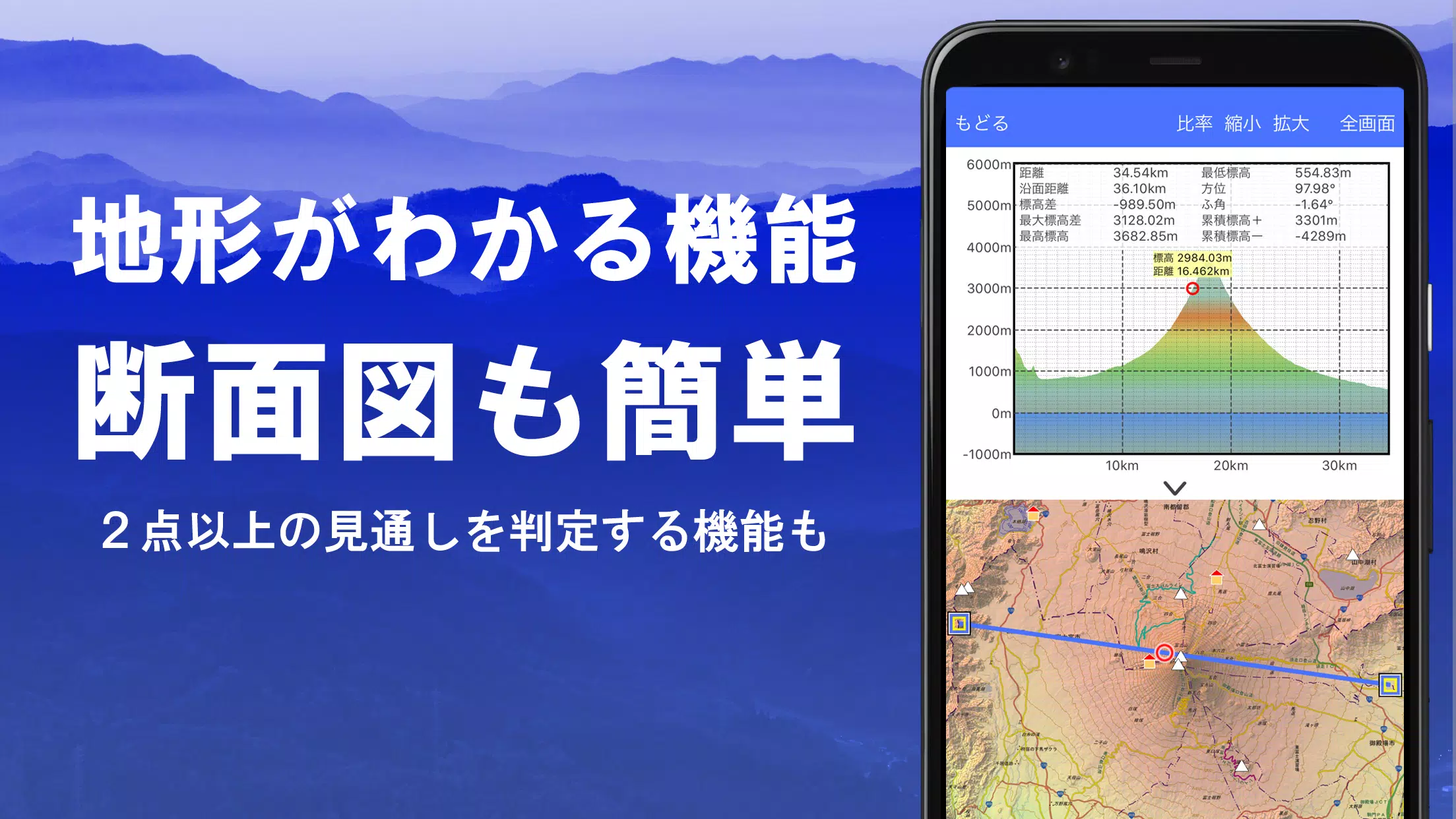
2. Cross-Section and Viewshed Creation
Easily generate a cross-sectional profile from any point on the map.
Includes the proven visibility analysis function from Kashmir 3D. Calculations account for the Earth's curvature and atmospheric refraction.
Ideal for route planning while hiking, determining radio wave visibility, and terrain analysis.
Where PLATEAU 3D city model data is available, create cross-sectional views that include buildings.
3. Elevation Palette Function
Customize the map background color using the elevation palette. Apply your preferred gradient in precise 1cm increments.
4. Panoramic View
Display a panoramic observation map from any location to identify surrounding mountain names. A 360° panorama synchronized with your smartphone's compass. Exceptionally powerful for mountain identification.
Display the sun and moon (including lunar phase). Useful for planning Diamond Fuji or Pearl Fuji viewings.
View the location of logged GPS points.
Can also generate panoramic views for international mountains.
5. GPS Functionality
Obtain location data using your smartphone's GPS and record your tracks.
Employs high-precision positioning suitable for serious mountaineering and outdoor use.
Graphically review recorded tracks with parameters like elevation change, speed, time, and elapsed time.
The point alert function notifies you via voice and sound when approaching a preset point.
Display photos linked to specific points.
Send the current map center position to NaviCon.
6. GPS Track Summary Playback
This feature allows for the consolidated playback of recorded track logs.
It compares timestamps from photos in your smartphone gallery and automatically displays matched images.
7. GPS Navigation Function
Features Track Navi, allowing navigation along a pre-set track using your smartphone's GPS.
An alert sounds if you deviate from the track.
This significantly reduces the risk of getting lost while hiking.
Additionally, supports route navigation for urban walking and point-to-point navigation.
8. GPS Data Editing Function
Handles GPS-related point, route, and track data.
Organize data into folders with a clear, tree-structured view.
Create tracks directly by drawing on the map.
Import and export data in GPX format from hiking websites and other sources.
9. Offline Map Usage
Access maps even in remote areas with no cellular signal, such as when mountain climbing.
The bulk download function ensures all scale maps for a specified area are downloaded at once.
Monitor download progress clearly. Avoids ending up without a needed map on-site.
Also includes a map caching function.
10. Map History Function
Remembers previously viewed areas, allowing you to easily return to a prior location.
11. Custom Map Compatibility
Import and use custom maps prepared with the Kashmir 3D map cutter.
Display and utilize your own maps or scanned maps within the app.
When using the map cutter, tile each image into segments of approximately 256 x 256 pixels.
Send the created KMZ file to Super Terrain via email or a cloud drive.
12. GeoJSON Compatibility
Read, display, and edit points, lines, and polygons from GeoJSON files.
Draw new shapes directly.
13. Print / PDF Output
Print any map area at a specified scale or export it as a PDF.
14. Integration with Other Apps
Exchange GPS data using GPX, KML, and GDB formats.
Enables data sharing with other apps, the PC software "Kashmir 3D," and trajectory data from hiking sites.
15. Backup Function
Back up all app data (excluding cached maps) and remove it from the smartphone.
Backups allow data restoration even if you delete the app or your smartphone malfunctions.
Also features automatic backup to Google Drive. Maintains up-to-date backups effortlessly.
Please consult the manual for detailed instructions.
16. About Billing and Features
Some features, including super terrain data maps, GPS track functionality, and cross-sectional views, require an in-app purchase. Paid status also increases the search results for place name searches.
●Fees
Annual subscription: 780 JPY/year
●Free Trial
A 5-day free trial is available upon first installation.
After 5 days, access to some features and maps will be restricted.
You will not be charged unless you complete a purchase.
To purchase, select [Settings] -> [Purchase to remove functional restrictions] within the app.
●Managing & Cancelling Subscriptions
You can check your renewal date or cancel auto-renewal as follows:
1) Open Google Play
2) Select "Subscriptions" from the menu
3) Select "Super Terrain"
●Price Revisions
Prices may be revised in the future due to feature additions and enhancements.
Early purchase is advantageous.
17. Terms of Use
The copyright holder and developer assume no liability for any consequences arising from the use of this application.
Upon first GPS use, you will be prompted: "Allow access to location services?" Please grant permission.
Continuous GPS use consumes significant battery power.
If your device is also needed for emergency communications, take precautions such as carrying a spare battery.
An easy-to-follow guide for the navigation function is available in PDF format below.
https://www.kashmir3d.com/online/superdemapp/superdem\_navi.pdf
On some smartphones, track recording may be interrupted or fail. This is due to power-saving features that force-close background apps, which cannot be controlled from within the app. This issue also occurs with other applications.
While turning off the screen may allow recording to persist briefly, this is not a permanent solution. Please be aware of this limitation.
程序描述
用户评价
发表评价
スーパー地形 - GPS対応地形図アプリ类似应用


热门应用
更多 +


3.3.4.102475 / 79.60M

v1.56.1 / 40.00M

热门新闻
- 1 发现2024年的顶级Android棋盘游戏 Feb 11,2025
- 2 《呼啸而过的梦想巡逻队》中的“风暴骑士”指南 Jan 23,2025
- 3 腾讯收购呼啸浪潮旗下黑游戏多数股权 Jan 05,2025
- 4 即将上映的新《星球大战》电影和电视节目:2025发行日期及以后 Feb 23,2025
- 5 Wuthering Waves在2.0更新中揭示了令人兴奋的添加 Feb 10,2025
- 6 揭晓顶级 Android 银河恶魔城:值得探索 Dec 11,2024
- 7 柔术快闪 Phantom Parade 全球发售日期公布! Jan 12,2025
- 8 EA 的《辛普森一家:Tapped Out》即将推出 Close Jan 09,2025
最新应用
更多 +

新闻杂志 | 30.4 MB
通往政府信息的门户通过这款便捷的手机应用程序,随时获取内政部的最新新闻、官方文件和直播活动。该 MOI 应用专为柬埔寨公民打造,直接从源头提供关键更新和信息。主要功能:实时更新:即时访问内政部发布的最新公告和新闻,让您及时了解政府的活动和决策。官方文件:轻松查找并下载官方文档,包括政策、法规和部门通告,为您提供可靠且精确的信息。直播流媒体:实时转播来自内政部的重大活动、官方仪式和新闻发布会,身临其境地体验重要时刻。及时通知:接收紧急新闻、计划事件和关键公告的即时推送提醒,让您始终了解内政部的重要

新闻杂志 | 32.0 MB
通过我们直观且易于使用的浏览工具,探索所有报纸。
使用自定义网页浏览软件,访问超过100个网站以及您最喜欢的报纸网站。
您可以轻松添加或删除书签,以便快速访问任何网站。

新闻杂志 | 39.6 MB
作为结合移动应用与网站的综合数字平台,香港 01 为港人提供全方位的互联网生活服务。
【全方位新闻及信息枢纽】
香港 01 提供全天候实时新闻报道,涵盖本地港闻、国际头条、编辑观点、天气预测以及独家调查报道,助您全面了解社会事务并洞察深层的社会趋势。
财经频道每日为您剖析港股动态及全球金融走势。专家分析助您把握市场脉搏、发掘投资机会,内容更延伸至楼市及个人财富管理策略。
娱乐新闻频道为您提供最快的明星动态、独家专访,以及港台韩剧美日剧集的最新资讯。
体育迷可信赖我们对奥运会、国际足球、NBA 赛

个性化 | 12.9 MB
ADW Launcher 2:一款超越安卓桌面定制化的蜕变之作。你可能以为这款有史以来最经典、最受赞誉的启动器已经不再更新,认为时间只是一条简单的因果链条。然而,从更宏观的角度来看,这几乎就像我们在三年前就发布了这次重大更新,只是你未曾留意罢了。请放心,我们深知并非每个人都能抽出精力——哪怕只有 1.21 吉瓦的电!——来关注这些细节。话虽如此,我们始终密切关注谷歌关于应用选项和设置的指导方针,并进行了广泛的讨论。但既然能言善辩并不等同于智慧,我们决定反其道而行之。毕竟,没有选择的自由,就没有真


新闻杂志 | 10.50M
Journey back in time and dive into the captivating world of the Bible with this remarkable Bible Stories app.It features 116 thoughtfully chosen stories, each one is not only faithful to the original texts but also told in a way that’s simple for rea
专题
更多 +